Highly requested: This is the ‘that’ll be for a later entry’ I teased on the Exploring the Kelso Dunes–A Hidden Gem in the Mojave Desert post.
October 9, 2018
You know, it’s really good to know people. Especially people who are property managers for rental homes in the pristine parts of Scenic 30A, the road hugging some of the most beautiful beaches, like ever, along the Florida panhandle. I just call it the fancy part west of Panama City Beach, away from most tourists.
Let’s rewind: less than 24 hours ago, Greg Truelove (who else?) blasts into the room rambling about some low category hurricane off the Gulf Coast (all while I’m still shaking off yet another weird dream) and we just haaaaave to go!
If you know us, you know we couldn’t resist. All this fuss while I was half awake wasn’t for us to start prepping for hiding, it was so we could run towards the chaos, not from it.

Brewing since October 2, Hurricane Michael rapidly developed into a well-constructed convection, a direct threat churning right in the center of the Gulf, between Mexico, Cuba, and Florida’s panhandle. From what started as a system, it then energized into a tropical depression just 12 hours after it was declared a cyclone in just a mere few days. Then October 8th came, the day the hurricane was officially named, and also when we heard the news, packed our gear and headed down.
We do what we always do… leave, and figure out the rest on the way, as things usually have their way of falling into place. We called one of our friends (our favorite cook!) who had recently moved to Destin, and she knew a property manager for some of those gorgeous sought-after vacation homes off 30A spanning from Inlet Beach all the way down west towards Destin.
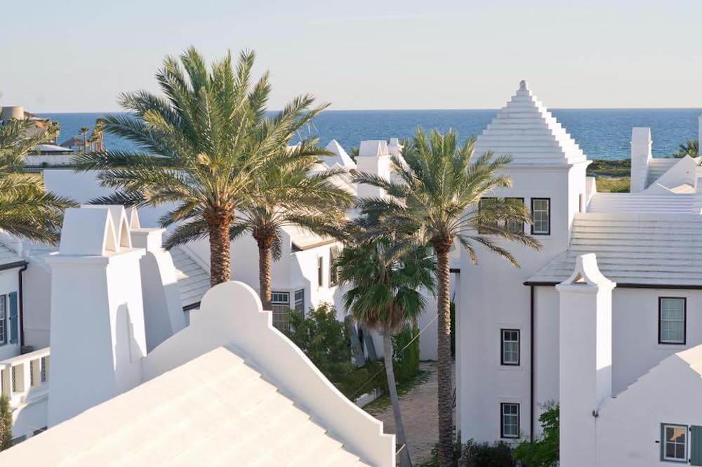
Thanks to our friend, about halfway through the drive, we had our given address, located in one of the most desirable areas off 30A. This house nested near Alys Beach, just one of the most luxurious best-kept secret communities on the Gulf Coast! Alys Beach is Florida’s own Santorini, Greece.

Anyway, Spoiler Alert: I lived. These communities are certified hurricane-proof, tested by me, the one who has never experienced a hurricane ever. And here we are, racing towards the storm while everyone else is racing away on the evacuation route. We drive in, while they drive out.
So about five hours after leaving Atlanta, the evacuation window was closing, and we arrived at our destination house to ride out the hurricane. The projected path was still narrow, yet unclear at the time, and it hadn’t risen to Category 5 just yet.
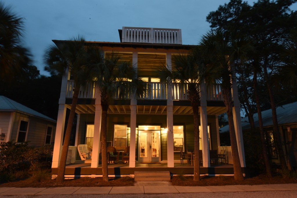
While arriving, we met a couple just across the way, tirelessly boarding up their windows. So, these are big, beautiful vacation homes–ours had three floors with five bedrooms, and a ton of windows that won’t get boarded up. The couple was actually from Atlanta, too, and they shot us a furrowed brow when we announced we came down for the hurricane, as they drove all that way just to board up and go back home to safety. The couple did give us a pro tip, though–the intimidating storm surge prediction won’t affect this area, as the beaches off 30A sit high above a bank, unlike Panama City Beach, who sits just at sea level.
The sun fell on October 9, and the hurricane jumped categories overnight.
What was now a Category 4 hurricane, and the evacuation window is now closed, I got a little panicked. I knew this was a mistake! I could be home right now but nooooo! I sat alone glued to the TV when I received a call from the property manager, ordering me to turn off The Weather Channel (how did she know?!) and that the storm is going to be wild for a few hours, but we will be fine. The community is fairly new and high income, which means all these buildings were built after the catastrophic Hurricane Andrew. So the windows, who underwent some interesting tests, are virtually disaster-proof. I also observed the surrounding trees as they stood shorter than the house, so not another worry came about them.
Just across the street lay the beach, lined with even bigger homes, some still under construction. The waves were rocking high and crashing greatly, with the water reaching all the way up to the foot of the staircase accesses. When we’re usually used to walking through yards of nice, white sand just to be touched by the ocean, today it met us immediately upon arrival, so we stayed high above atop the steps.
The gusts were gnarly, too, at one point I ran to the car for shelter from a gust almost sweeping me away into the wind at one point. But one thing I remember is all the large dragonflies, doing their normal thing, hovering over or near the plant life lining the beach. I was a little remorseful that I couldn’t rescue them all from what’s about to come.
October 10, 2018
The hurricane will make landfall today. We went on our regular beach runs and watched the clouds grow a little darker, the wind whip a little wilder, and the waves rise and fall as dramatically as ever. There’s not a lot of other people or animals in sight, even the dragonflies were missing from the picture.
We did our back and forth to and from the beach all morning, and then we got the word: the eyewall is making landfall near the Tyndall Air Force Base and Mexico Beach, about 10-15 miles east, as a Category 5 hurricane sustaining 155 mph winds, right now. We were actually viewing the beach in that very moment (oops!) so we scurried our way back to our Seacrest shelter and rode out the storm as it completely slammed into the panhandle.
Our friends were right, it did get quite wild for a few hours, exactly. The house was standing fine, but the screeching of the trees scraping the roof did quite a number on my creep meter as the gusts were wailing at record-breaking speed. Then we lost power.
The storm passed, and we were overcome with deafening silence.
The sunset was pretty awesome, as the blanket of clouds shrouded the sky, moving north towards my home in Atlanta, but had cleared just enough for a show from the sun on the horizon. I did see that the dragonflies had returned along with me, back to their regularly scheduled hovering.
But I was too anxious about others who may have been hurt and needed help at that very moment. I also worried about my friends and family in Georgia, who some would be met with trees in their homes a few hours later.
Ugly lesson: the anxiety didn’t peak while prepping for or during the storm.
For me, the anxiety arrived and stayed as a guest in my body long after when the death toll rose, the sad stories, and the rescue teams still working nonstop. Natural disasters aren’t for the weak. They’re for no one.
The real anxiety came with the messages of strangers, local and far away, pleading others like me who were marked safe to check on their loved ones. I didn’t realize just how much use I would be after marking the “has information” option on the Hurricane Michael Crisis Facebook page. I did the best that I could, but I simply couldn’t reach all the family’s loved ones’ requests to do a drive-by check. We could only check on a few but had to turn back after a while for our own safety.
The Cajun Navy, a nonprofit organization created during the Hurricane Katrina disaster that dealt great damage to Louisiana, had come to help. The National Guard also posted a welfare check form to fill out. At the very least, I spread this information which did help a few.
With most of the panhandle blacked out that night, the temperatures fell and I could hardly sleep from worry.
On the top balcony, Truelove took advantage of the darkest sky in ages and took some cool star shots (check out the video). Thoroughly creeped out in such a large, dark, and new home, I had to sleep up in the room equipped with a minibar and a couch attached to the top balcony where he was to gain a little ease. After finally able to drift to a light sleep, every half an hour or so, I would wake from a bright light and a hum–the Coast Guard doing their rounds by air.
When we stepped outside for the first time just after the hurricane passed, no windows were broken, all the homes nearby suffered zero damage. We got out alive and we able to drive around and survey. But this was Rosemary and Alys Beach. The more east we drove, the worse the damage scaled.
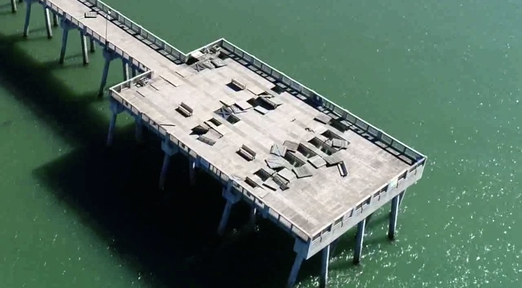
The next day, October 11, you couldn’t find a cloud in the sky. Drone footage we shot of the Miller County Pier in Panama City Beach shows some of the hefty damage from the waves below.
We didn’t know just how devastated Panama City was when we left it the following day.
Three weeks later, we got a taste while heading over the bridge. Even after three weeks, we saw steel wrapped around trees, above-ground swimming pools plopped in front of fast-food restaurants, flattened businesses, and destroyed homes and graveyards. Mexico Beach wiped away entirely. Mandatory curfew, displaced people who had lost everything they had.
We got lucky.
We were able to leave it all behind and drive away from the destruction, while some are still suffering and recovering from a fraction of the $25 billion bill or mourning one of the 16 deaths.
This storm encounter was intended for a thrill–and, well, I got that in full force–in all the good and bad ways. So much can change from sitting at home to bracing a hurricane 48 hours later, out of state, asking myself WTF have I done agreeing to coming here.
I survived the strongest hurricane to make landfall in the Florida panhandle while others didn’t. I am forever grateful and humbled for my friends who provided me a safe place at Seacrest.

My fiance has a condo there and was lucky enough to be out of the country when it hit. I got to see the devastation awhile later and it was horrific. They are still rebuilding things to this day.
LikeLike
I’m glad your fiance was away during the storm! It was quite devastating, and I’ve met people here in Atlanta who had moved here from Panama City Beach because of the mess it caused.
LikeLiked by 1 person